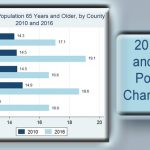
June 22, 2017. The U.S. Census Bureau released its 2016 state and county population characteristics for the nation, states and counties today. They include population estimates by age, sex, the 5 major race groups and Hispanic origin between April 1, 2010 to July 1, 2016. The Census Bureau press release regarding this data is available. ...
Read More
Featured
March 16, 2017. DBEDT has released the report “Native Hawaiian-Owned Firms in Hawaii’s Tourism Sector”. To obtain the report, click here. The executive summary begins with “According to the U.S. Census Bureau data, Native Hawaiians owned a total of 13,147 firms in Hawaii in 2012. 3,972 or 30.2 percent of these firms were in the ...
Read More

December 9, 2016. The U.S. Census Bureau released its 2011-2015 American Community Survey (ACS) 5-year estimates on December 8, 2016. The estimates are based on the annual American Community Survey conducted by the Census Bureau which include social, economic, demographic and housing characteristics of Hawaii’s population. The Census Bureau releases 5-year data for all census ...
Read More
April 23, 2015. DBEDT released its “Real Estate and Rental and Leasing Sector in Hawaii” report today. It contains sector information on Hawaii’s business establishments and their activities based on the 2012 Economic Census data. Highlights of the report are shown below. Based on the 2012 Economic Census, there were 1,919 employer establishments in Hawaii ...
Read More

April 16, 2015, DBEDT released statistics brief Commuting Patterns in Hawaii. This brief depicts commuting patterns of working residents in Hawaii. Changes over time are shown using data from the 1980, 1990, and 2000 decennial census and American Community Survey 5 year estimates for the period of 2009-2013 to capture the most recent information on ...
Read More
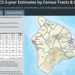
New interactive maps depict Census Tract and Legislative District boundaries and selected data profiles using the latest 2009-2013 American Community Survey 5year data estimates. Joint project with Research Economic Analysis Division and Office of Planning GIS Program
Hawaii’s Population Estimate
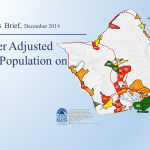
Statistics Brief, December 2014 Commuter Adjusted Daytime Population on Oahu
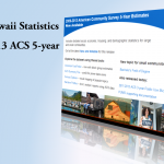
2013 American Community Survey 5-Year Data Released by the Census Bureau Today